One longer-running campaign I ran evolved organically over time. I’ve revisited it a few times with an eye toward running it again or, at the least, culling some of the better (and less derivative) ideas that grew out of it.
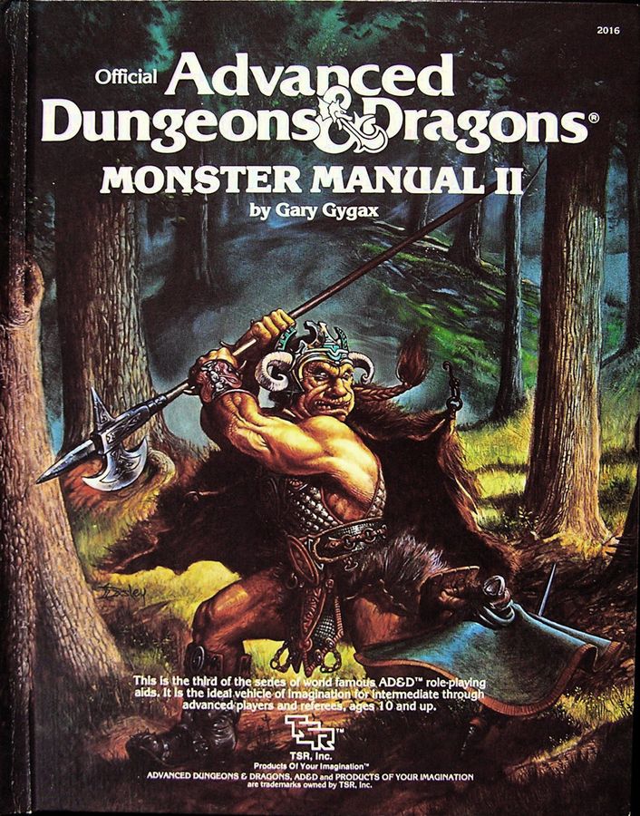
Monster Manual II cover art by Jeff Easley
The campaign began in the titular Glen with the well-worn idea that the location would serve as the home base and jumping off point for a series of adventures, much same way as TSR’s village of Hommlet. The Glen marked the northernmost outpost of a large unnamed kingdom. From there, the player characters would initially investigate rumors of a possible goblin threat that would turn out to be the harbinger of an all-out invasion. The visual inspiration for that initial foray came from Jeff Easley’s cover art for the Monster Manual II and the idea of a monster-haunted forest (much like Mirkwood as Iron Crown’s MERP setting was an influence, but rather more deciduous and slightly less dangerous à la the Trollshaws).
As I added elements to the game and the threats escalated to match the level of the characters, the Glen was quickly left behind in favor of an extended foray forever deeper into the lands where evil forces had gained a far greater foothold than anyone imagined. The idea of locations linked by a larger story arc obviously drew in great deal from the Giant and Drow series, but taking place almost entirely overland and sharing far more with the Dragonlance series. I was also inspired by the military campaign style of Glen Cook’s Black Company series that first came out at that time.
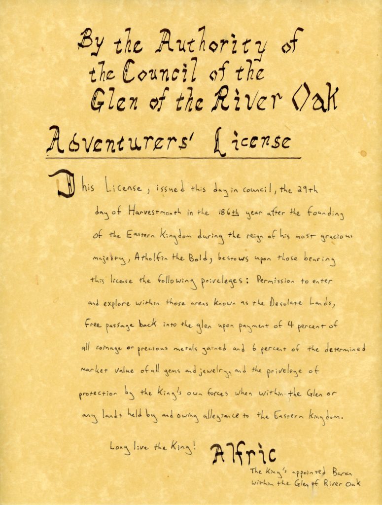
Adventurers’ License One of the first player handouts of the game
In a previous post about a long-running Gamma World campaign of mine, I discussed the characters traveling eastward to confront rising threats there. I had plans for a further stage of that campaign that never came to fruition where the looming threat becomes a direct confrontation in a race to uncover sites of the Ancients.
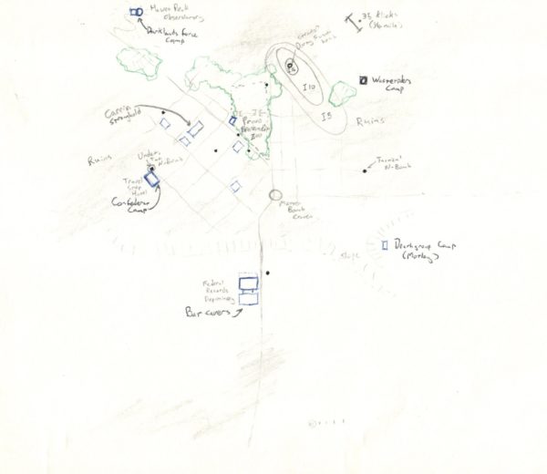
I thought that I had only planned that part and forgotten that I had done a great deal more planning and mapping until I uncovered a stash of old gaming material in my mom’s attic. As I scan and organize that material, here’s a couple of maps I made.
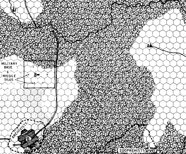
The first of these was from around the time the campaign ended. Different groups have converged on the ruins of what was previously the city of Provo in search of key information to the location of an ancient site. The characters may interact with allied groups like the Deathgroup and the Confederat, while competing with the Darklands force and the Wasteriders members. Meanwhile, the inhabitants of Provo, a well-fortified group of carrin control the area from their eyrie apart from a group of mutants calling themselves Batcavers who are powerful enough to oppose the carrin overlords from their underground tunnels.
I also conceived the central fortress of the Darklanders, based heavily on the art from the cover of TSR’s Gamma Base adventure (GW8). This location wasn’t intended as somewhere the characters would travel to, being rather like Barad–dûr in Middle Earth.
I wish I had made more maps like the above to cover the various bases and staging areas of the Darklander invasion forcers. Among other things, it’s interesting to conceptualize what sort of support and Ancient technology would be needed for the terraforming machines that I planned as part of the invasion’s vanguard.
When Dungeon Adventures first started publication and I set my sights on publishing an adventure with that magazine not long after. I had played TSR’s Oriental Adventures in college and had run FGU’s Bushido, so the logical dovetailing of these experiences with my Japanese Studies degree was to write an adventure using the OA setting. In due course, the editors at Dungeon Adventures responded to my query letter with the green light to submit a full-length adventure for their consideration.
The adventure I authored, The Lost Temple of Takako Province, was… not great. Looking back at a remove of several decades, it’s pretty clear to me some of the major reasons that the editors rejected it. It wasn’t badly written and the map I created was quite serviceable. It was just rather lackluster. It lacked depth, it didn’t tell a compelling story, the playing time was short compared to the length of the adventure, and it failed to build any sense of suspense.
What I wrote pre-dated some of the influences that I would have happily drawn on. For example, there’s a scene in Koji Suzuki’s novel Ring (Ringu) where the main characters visit the holiday resort together to find the well where Sadako is buried. The atmosphere of the setting combined with the culmination of the investigations is deeply unsettling. Had I had the opportunity to read material like that, finding the temple would have been part of the adventure and the approach there the culmination of that investigation rather than the adventure starting point.
If I had done more research, I would have learned much more about youkai instead of just relying on the prevalent bakemono and their kin as they existed in the rulebook. The ultimate enemy the group was to encounter was a goblin spider, a rather lackluster choice, though I chose it for an appropriate Challenge Rating and it’s mimicry abilities. The inhabitants of the temple building should have been an opportunity to introduce a few new creatures that would have rounded out the atmosphere and kept the characters off-balance on how to deal with the final encounters. The flow of the adventure was fairly linear with the players getting to the main temple after contending with some somewhat treacherous terrain and a few random encounters. The interior of the temple was a fairly standard sweep-and-clear with encounters varying based on how stealthily or quickly the adventures made their way through it. Overall, I think my inspiration for the flow was the TSR adventure Secret of the Slaver’s Stockade (A2), which remains a favorite of mine to this day, but not the best template for the adventure I wanted to create.
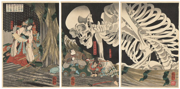
The book Anno Dracula – One Thousand Monsters by Kim Newman is what got me really thinking about this old work of mine. Quite simply, Oriental Adventures was a mess of different Asian cultures and some very confusing generalizations. Many things were simplified or dropped in order to be playable in the D&D game system. Other systems weren’t much better with the likes of FGU’s Land of the Rising Sun where the creatures feel more like reskinned versions of the beasts and Arthurian creatures from the Chivalry & Sorcery. Part of it is an issue of time period where newer eras are grafted on to an older time and part is an issue of the same failure I made which is to research the setting in sufficient death. So whereas Bushido classes youkai as apparitions and, therefore, a sub-category of yurei (ghosts), I think the consensus is that youkai is a catch-all for every kind of strange creature, be it ghosts, bakemono, kami, or animate objects in the sense the term was used during the Edo Period. Which is certainly reasonable if you’re incorporating something like Le Morte d’Arthur into your pseudo-European fantasy campaign. I think it would be great to run adventures with a flaming cart wheel or a giant skeleton.
Mitsukuni Defying the Skeleton Specter Invoked by Princess Takiyasha by Kuniyoshi. This art is cited as the inspiration for the Gashadokuro
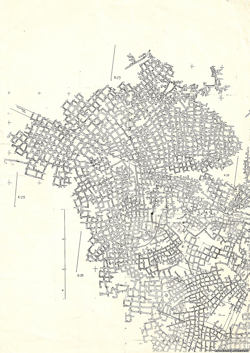
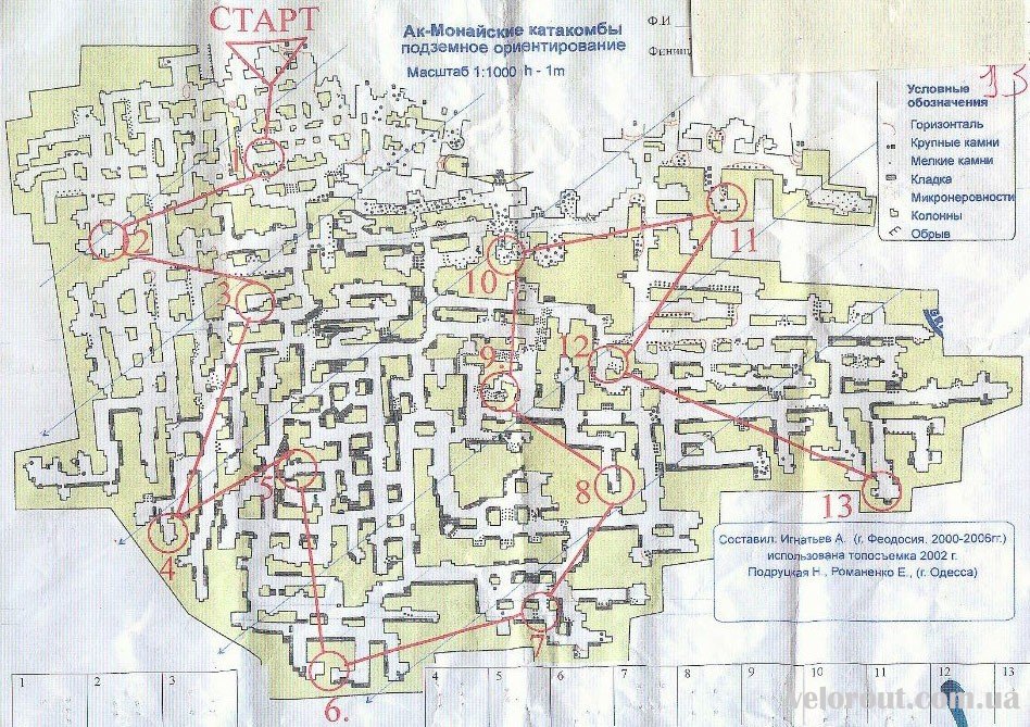
If you’re like me, you’re familiar with the Paris catacombs. They’re not the only such network of tunnels and many exist all over the world. Unlike limestone caverns, which are formed through the natural actions of nature, a large number of these tunnels were expressly for the purpose of mining limestone for the use of construction. As a result, they occur alongside populated areas like Paris, Maastricht, and Odessa.
An article in the Atlas Obscura discussed the entry for the Odessa Catacombs. Like the Paris catacombs, they were used to extract limestone, though apparently of a somewhat more recent vintage, dating back to the 1600s and with the greatest activity in the 1800s.
That anachronism aside, any section of the catacombs might be used by a gamemaster looking for a subterranean map. Even that might not be a stumbling block, given how many high-fantasy settings are littered with buildings owing more to the likes of Neuschwanstein Castle than to early medieval castles.
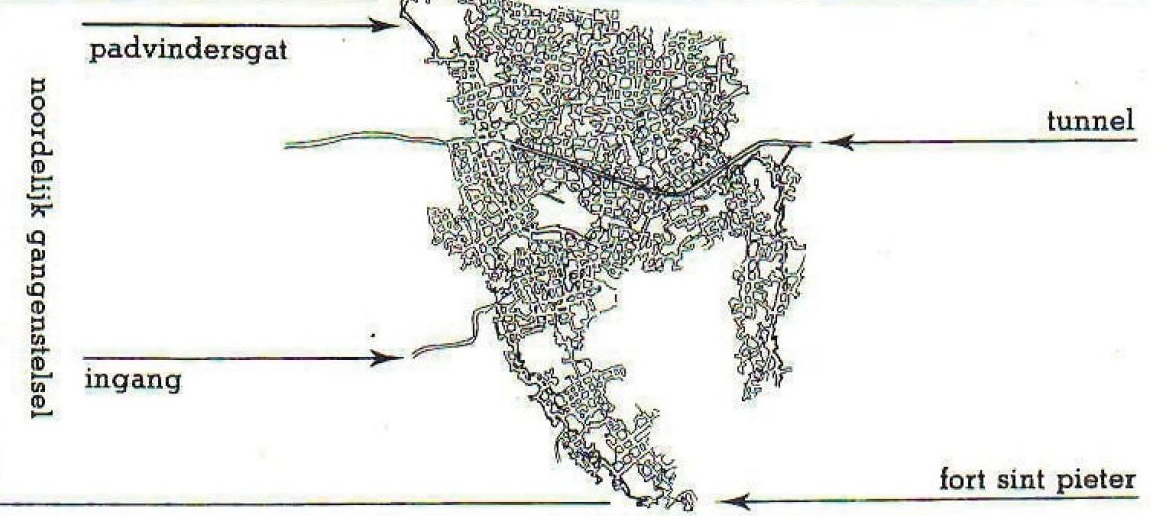
As caves go, the Cave of Dunmore in County Kilkenny, Ireland, is a bit on the small side and not too terribly exceptional. As real-world locations go for the basis of game settings, there’s almost more going on in the visitor center than there is in the actual cave, apart from the somewhat dramatic sweep of the entrance that drops down steeply to the subterranean opening.
The story behind the cave and its history as the site of a Viking massacre is far more interesting and provides plenty of fodder for adventure, particularly if the dark atmosphere and reputation among the inhabitants is played up. For the gamemaster in a hurry, it’s relatively easy to make or find maps of limestone caves that are much more extensive and adapt them for adventure and to borrow all the description needed.
“we having, when led to the cavern for scenic illustration of the facts of this history, adventurously plunged our hand into the clear water, and taken therefrom a tibia of unusual length; and, indeed, the fact that such human relics are there to be seen, almost a quarter of a mile from the light of the earth, must, if we reject the peasant’s fine superstition, show us the misery of some former time of civil conflict, that could compel any wretched fugitive to seek, in the recesses and horrors of such a place, just as much pause as might serve him to starve, die, and rot.” – from the Dublin Penny Journal, 1832.
Colorized image of Cave of Dunmore via Moja Zielona Irlandia from the original in the Dublin Penny Journal
One of the things I like as much as maps and geography is linguistics and anything related to the study of language. When it comes to maps, the naming of places is something I’m particularly fond of. Contrariwise, there’s nothing worse than encountering a map for a book or game adventure littered with the most overblown of PanCeltic place names or where the naming is intended to sound exotic through the addition of apostrophes (or sometimes both!).
I think one of the best ways to learn how to create realistic maps is to study real maps and to study why certain places are named the way they are. Names evolve and change over time as successive peoples enter an area and either use existing names given to places by their predecessors or attempt to translate them in some fashion. In some cases, the two cases (descriptive versus folk etymology) can be very hard to differentiate.
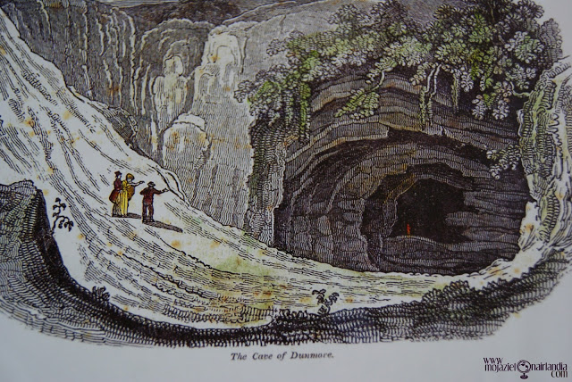
For those creating their own maps, there’s much more flexibility in the etymology of place names and the opportunity to play with the names while simultaneously developing the place names, cultures, history, and language of the area. Descriptive names are easy and incredibly common. Rivers are often named simply “River” such as England’s Thames, Tame, and Teme, and also Avon from a different root. The Atlas of True Names translates the Thames as Darkwater, but that seems more like over-etymologizing since the original root can be used to mean “dark” or “river”, implying that it would be more like a river in the sense of a dark and deep-flowing body of water, much like brook and torrent describe two very different types of streams. Other rivers are simply “river” with the addition of an adjective, such as Mississippi derived from the Ojibwe misi-ziibi (“great riverâ€) or Tolkien’s Anduin and Brandywine (Baranduin).
Darkwater (River Thames) from the Atlas of True Names
So whether your fictional kingdom’s river is called The Long River or Darkwater or, simply, The River, there’s no wrong way to do it. Though I beg aspiring fantasy cartographers to not be too liberal with place names like Skull Mountain or Ul’za’kamm’dng. Simple and consistent is always better and you can get a lot of mileage out of simple fantasy base roots for river and mountain. For myself, I prefer Ered Luin to the Blue Mountains, but that might just be because I’m a fan of Elvish etymology, even if it is pretend.
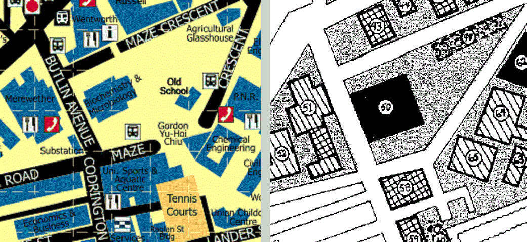
One of the things I liked about Aftermath’s Operation Morpheus is the idea of exploring Sydney University or a version thereof that’s been reimagined as a place for an adventure. Most of the adventure takes place in the (imaginary) bunkers underground, vast complexes of offices, labs, and facilities that have survived.
From a mapping standpoint, it’s great that there’s so much to explore, all mapped out and detailed enough to allow the gamemaster to easily expand upon. On the other hand, because it’s a game adventure, much of the detail and quirkiness of the corresponding real places has been ironed out. For example, the Biochemistry and Microbiology building is reduced to a square and smaller buildings have eliminated entirely.
The University of Sydney side-by-side real world and Operation Morpheus map details
For me, the real missed opportunity is that there’s no network of tunnels typical of many universities, at least in the United States. While the adventure layout means that the party must venture to the surface and gain access to other buildings to explore other complexes, navigating tunnels would allow for more three-dimensionality below the ground and provide additional smaller areas to explore. Perhaps I’ll try creating a map or two of my own to explore some of those ideas.
Back when I wanted to be a published gamer, I submitted an adventure to Dungeon Magazine. It was my one and only submission and left something to be desired in terms of length of play and ways to draw the player in, being a foray into an adventure for TSR’s recently-published Oriental Adventures and being a little too heavily influenced by the adventures published for FGU’s Bushido, particularly Valley of the Mists. For the creation of the map accompanying the adventure, I wanted to create something that had a little more polish than my typical hand-drawn maps. I had been reading the Lensman manga, which I believe was the Moribi Murano version from the anime of the same name, and I learned about using screentone cut to shape to for shading. I duly made a trip to the University Bookstore and acquired sheets with the patterns I needed to fill the areas on my map with forest.
In this day and age, it’s far easier to accomplish the same effect digitally using texture fills or brushes with the designs you want. It’s also much less time-consuming than painstakingly cutting shapes using an X-Acto knife. I acquired old-school Letratone textures for forests, mountains, and more, created as tiles from scans of the original sheets by John Cooper. The look definitely evokes the feel of the original first-edition area map, but I think it works a little better in color. I’m not sure if it’s the feel I’m looking for on my Gamma World map I’m redesigning, but I love the look and the possibilities, so I may find another project to use it on.
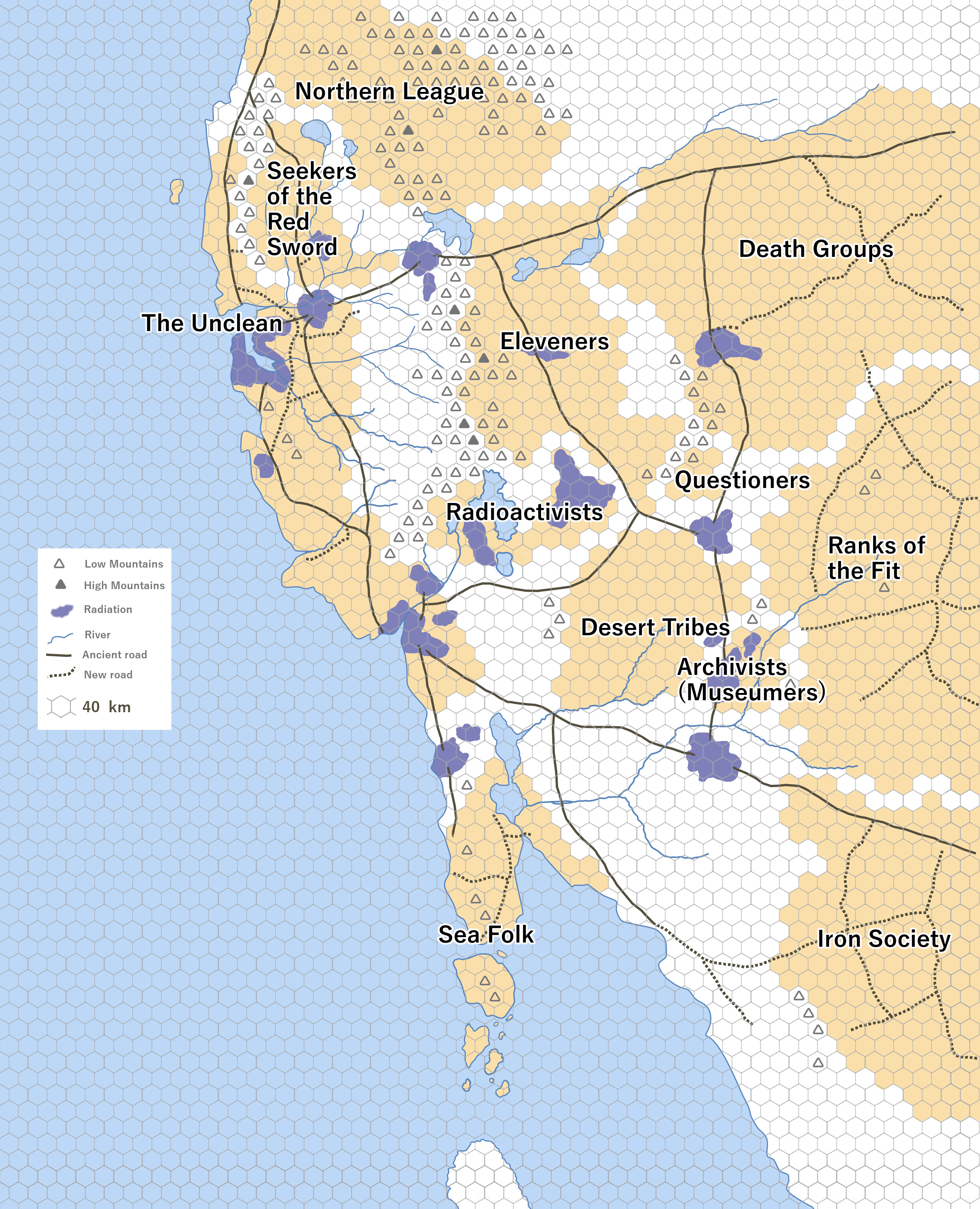
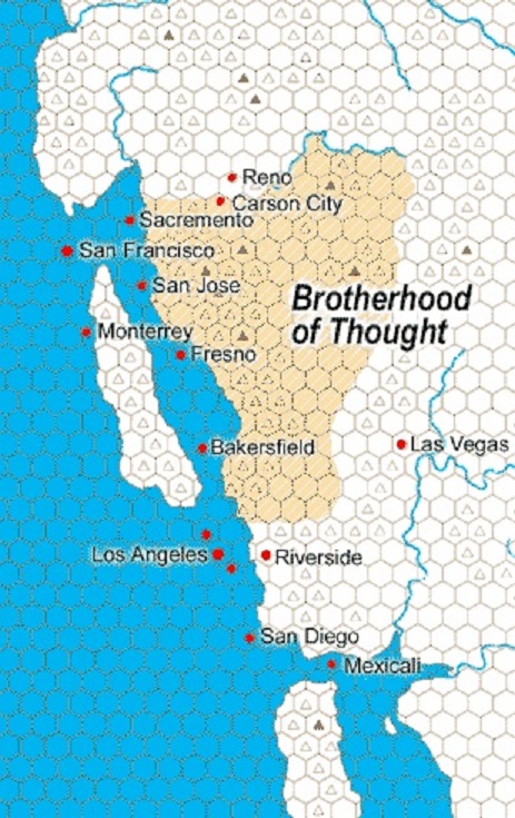
Creating and editing digital maps are great for repurposing maps on demand. I’ve never been fond of hex maps outside of their uses for wargaming, but I’ve enjoyed all the iterations of the maps in the various editions of Gamma World. The maps of the United States post-apocalypse are primitive, yet evocative of a shattered landscape populated by various cryptic alliances that, to me, are more interesting that those portrayed in something like the Morrow Project.
In my campaign, cryptic alliances exist as purely political divisions rather than something like as groups that may or may not control territory. A good example would be the Created, the alliance of androids that infiltrate other groups to further their own agenda. Though not shown on the map, I can imagine such a group existing in my world as a machine-dominated nation with human and mutated animal inhabitants who live alongside them with a philosophy like the Followers of the Voice, subservient to their metal masters.
Not shown on my map are the modern day locations what, to the typical Gamma World inhabitant, would be the ruins of the Ancients. In keeping with the style of the original 2nd Edition map, I also only showed the areas of direct influence of the different groups since it’s difficult to show overlap with the style (such as the disputed region that exists between the Eleveners and the Death Groups that is, instead, left entirely unshaded). I also primarily followed the hex grid for areas of influence since it flows more naturally around the mountains that naturally divide regions rather than following rivers.
Gamma World original campaign hex map showing political divisions and features
Gamma World 2nd edition west coast showing the Brotherhood of Thought cryptic alliance
The Gaslight and Steam website is my place for various musings and experiments. Most of the things you'll find here are related to tabletop RPGs, video games, and movies. I also go on about my fascination with maps, particularly as it relates to the previously mentioned topics. This blog is maintained by David Bennett.