The portfolio and blog of David Bennett

Author: David Bennett (Page 2 of 6)

Mapping Monday: Adventures in Caves

As caves go, the Cave of Dunmore in County Kilkenny, Ireland, is a bit on the small side and not too terribly exceptional. As real-world locations go for the basis of game settings, there’s almost more going on in the visitor center than there is in the actual cave, apart from the somewhat dramatic sweep of the entrance that drops down steeply to the subterranean opening.

The story behind the cave and its history as the site of a Viking massacre is far more interesting and provides plenty of fodder for adventure, particularly if the dark atmosphere and reputation among the inhabitants is played up. For the gamemaster in a hurry, it’s relatively easy to make or find maps of limestone caves that are much more extensive and adapt them for adventure and to borrow all the description needed.

“we having, when led to the cavern for scenic illustration of the facts of this history, adventurously plunged our hand into the clear water, and taken therefrom a tibia of unusual length; and, indeed, the fact that such human relics are there to be seen, almost a quarter of a mile from the light of the earth, must, if we reject the peasant’s fine superstition, show us the misery of some former time of civil conflict, that could compel any wretched fugitive to seek, in the recesses and horrors of such a place, just as much pause as might serve him to starve, die, and rot.”
– from the Dublin Penny Journal, 1832.

Colorized image of Cave of Dunmore via Moja Zielona Irlandia from the original in the Dublin Penny Journal

Mapping Monday: Video Game Levels

Levels for video games are curious beasts. Levels for games that have some degree of realism, such as first-person shooters and racing sims are even more curious. In many cases, the designers must balance the needs for those levels to be both visually interesting and fun to play while also bearing some semblance to the real world, even if that real world is filled with lava lakes and floating castles. Sometimes there are also technical constraints such as draw distances to contend with or the manner in which the in-game camera behaves. A recent visit to the Museum of Pop Culture (MoPOP) got me thinking about how simply lifting a real-world place to create a game level is generally a bad idea, though MoPOP is so thoroughly bizarre that it would work. In fact, it’s architecture is sufficiently confusing that the map provided to visitors doesn’t even try for a high level of detail and instead simply shows how the different areas are connected, either by halls, stairs, or elevators.

When I applied for my first game designer with Microsoft Games Studio, part of the application involved answering a series of questions about game design and called for the design of a sample Crimson Skies level. The idea was to build a simple (1 page) mission in the current Crimson Skies universe, limiting it to the weapons and planes in that setting. What I came up with was a raid in Appalachian Territory in order to clear the way for a bombing run on a band of Hell’s Henchmen.

Crimson Skies designer test – mission map

Crimson Skies designer test – mission description

Knowing what I know after having worked on the game, I’d add much more vertical elements to the game, exaggerating the depth of the river valley and break up the valley walls with ravines, add bluffs of varying heights, and increase the number of buildings. One of the areas in Crimson Skies: High Road to Revenge, the outlaw base of Sea Haven, was a caldera with exaggerated vertical scale with an exterior littered with the wreckage of zeppelins and an interior criss-crossed with walkways and girders. All of it made for interesting missions along with plenty of out-of-the-way places to hide tokens. Interestingly, the game was originally conceived with multi-modal play where the player would occasionally exit their plane and run around. When that idea was scrapped, there was no need for detailed human-scale areas and focus was given almost entirely to levels playable with airplanes apart from the gameplay around manning turrets.

Sea Haven main area level mesh in Maya for Crimson Skies

Sea Haven top view of main area level mesh in Maya for Crimson Skies

Mapping Monday: Kent Through Time

As a long-time fan of post-apocalyptic fiction and continuing last week’s discussion of toponyms, I thought I’d toss out three maps of the County of Kent in England. They’re very from very different time periods and the features on each are also dissimilar, but they’re all recognizable of the same area.

The first map is of Kent during the Roman occupation (and also covering Sussex, Surrey, and neighboring areas) that shows the extent of The Weald at that time (also known as Coit or Coed Andred, Silva Anderidae, or Andred’s Wood). Very little remains now apart from small forests like Ashdown Forest at the center of the High Weald and, incidentally, the basis for the setting of Winnie the Pooh stories. The second map is a postcard map of modern Kent (via Alwyn Ladell) that shows The Weald in the lower left. The third map is a future England as imagined by Russell Hoban for his book, Riddley Walker where the place names combine language drift and folk etymologies (or “eggcorns”). The place names are still recognizable in all three despite the changes in name over time.

As a case in point, all three maps feature the port city of Dover. On the first, it appears as Portus Dubris, a latinised name derived from the name given by the locals and meaning something like “river port” or “deep water port” (in the sense of the word “water” deriving from the root “deep”). The modern map features its present name, which is closest to the French name (Douvres). The imaginary future maps renders it as Do It Over, a curious expansion as a folk etymology like many other place names similar split and expanded in the book. The key in the map of the future is that it’s logically consistent with how names evolved from the names in the past.

The Forest of Anderida during the Roman Occupation of Britain from A History of The Weald of Kent with an outline of the Early History of the County, Volume I. by Robert Furley

Postcard map of Kent, the Garden of England. Drawn by M F Peck for J Salmon, Ltd., Sevenoaks.

Riddley Walker map of Kent from the book by Russell Hoban

Mapping Monday: Toponyms

One of the things I like as much as maps and geography is linguistics and anything related to the study of language. When it comes to maps, the naming of places is something I’m particularly fond of. Contrariwise, there’s nothing worse than encountering a map for a book or game adventure littered with the most overblown of PanCeltic place names or where the naming is intended to sound exotic through the addition of apostrophes (or sometimes both!).

I think one of the best ways to learn how to create realistic maps is to study real maps and to study why certain places are named the way they are. Names evolve and change over time as successive peoples enter an area and either use existing names given to places by their predecessors or attempt to translate them in some fashion. In some cases, the two cases (descriptive versus folk etymology) can be very hard to differentiate.

For those creating their own maps, there’s much more flexibility in the etymology of place names and the opportunity to play with the names while simultaneously developing the place names, cultures, history, and language of the area. Descriptive names are easy and incredibly common. Rivers are often named simply “River” such as England’s Thames, Tame, and Teme, and also Avon from a different root. The Atlas of True Names translates the Thames as Darkwater, but that seems more like over-etymologizing since the original root can be used to mean “dark” or “river”, implying that it would be more like a river in the sense of a dark and deep-flowing body of water, much like brook and torrent describe two very different types of streams. Other rivers are simply “river” with the addition of an adjective, such as Mississippi derived from the Ojibwe misi-ziibi (“great river”) or Tolkien’s Anduin and Brandywine (Baranduin).

Darkwater (River Thames) from the Atlas of True Names

So whether your fictional kingdom’s river is called The Long River or Darkwater or, simply, The River, there’s no wrong way to do it. Though I beg aspiring fantasy cartographers to not be too liberal with place names like Skull Mountain or Ul’za’kamm’dng. Simple and consistent is always better and you can get a lot of mileage out of simple fantasy base roots for river and mountain. For myself, I prefer Ered Luin to the Blue Mountains, but that might just be because I’m a fan of Elvish etymology, even if it is pretend.

Mapping Monday: Real-World Adventures

One of the things I liked about Aftermath’s Operation Morpheus is the idea of exploring Sydney University or a version thereof that’s been reimagined as a place for an adventure. Most of the adventure takes place in the (imaginary) bunkers underground, vast complexes of offices, labs, and facilities that have survived.

From a mapping standpoint, it’s great that there’s so much to explore, all mapped out and detailed enough to allow the gamemaster to easily expand upon. On the other hand, because it’s a game adventure, much of the detail and quirkiness of the corresponding real places has been ironed out. For example, the Biochemistry and Microbiology building is reduced to a square and smaller buildings have eliminated entirely.

The University of Sydney side-by-side real world and Operation Morpheus map details

For me, the real missed opportunity is that there’s no network of tunnels typical of many universities, at least in the United States. While the adventure layout means that the party must venture to the surface and gain access to other buildings to explore other complexes, navigating tunnels would allow for more three-dimensionality below the ground and provide additional smaller areas to explore. Perhaps I’ll try creating a map or two of my own to explore some of those ideas.

Mapping Monday: Maps with Screentones

Back when I wanted to be a published gamer, I submitted an adventure to Dungeon Magazine. It was my one and only submission and left something to be desired in terms of length of play and ways to draw the player in, being a foray into an adventure for TSR’s recently-published Oriental Adventures and being a little too heavily influenced by the adventures published for FGU’s Bushido, particularly Valley of the Mists. For the creation of the map accompanying the adventure, I wanted to create something that had a little more polish than my typical hand-drawn maps. I had been reading the Lensman manga, which I believe was the Moribi Murano version from the anime of the same name, and I learned about using screentone cut to shape to for shading. I duly made a trip to the University Bookstore and acquired sheets with the patterns I needed to fill the areas on my map with forest.

In this day and age, it’s far easier to accomplish the same effect digitally using texture fills or brushes with the designs you want. It’s also much less time-consuming than painstakingly cutting shapes using an X-Acto knife. I acquired old-school Letratone textures for forests, mountains, and more, created as tiles from scans of the original sheets by John Cooper. The look definitely evokes the feel of the original first-edition area map, but I think it works a little better in color. I’m not sure if it’s the feel I’m looking for on my Gamma World map I’m redesigning, but I love the look and the possibilities, so I may find another project to use it on.

Original 1st Edition Gamma World area map

Gamma World forest from original map

Mapping Monday: Gamma World Hex Maps

Creating and editing digital maps are great for repurposing maps on demand. I’ve never been fond of hex maps outside of their uses for wargaming, but I’ve enjoyed all the iterations of the maps in the various editions of Gamma World. The maps of the United States post-apocalypse are primitive, yet evocative of a shattered landscape populated by various cryptic alliances that, to me, are more interesting that those portrayed in something like the Morrow Project.

In my campaign, cryptic alliances exist as purely political divisions rather than something like as groups that may or may not control territory. A good example would be the Created, the alliance of androids that infiltrate other groups to further their own agenda. Though not shown on the map, I can imagine such a group existing in my world as a machine-dominated nation with human and mutated animal inhabitants who live alongside them with a philosophy like the Followers of the Voice, subservient to their metal masters.

Not shown on my map are the modern day locations what, to the typical Gamma World inhabitant, would be the ruins of the Ancients. In keeping with the style of the original 2nd Edition map, I also only showed the areas of direct influence of the different groups since it’s difficult to show overlap with the style (such as the disputed region that exists between the Eleveners and the Death Groups that is, instead, left entirely unshaded). I also primarily followed the hex grid for areas of influence since it flows more naturally around the mountains that naturally divide regions rather than following rivers.

Gamma World original campaign hex map showing political divisions and features

Gamma World 2nd edition west coast showing the Brotherhood of Thought cryptic alliance

Mapping Monday: Developing Cities

One of the more common issues I’ve seen with maps of cities in fantasy settings is their regularity. Short of a city being developed according to a master plan from the beginning or being rebuilt from scratch after a calamitous disaster, no city is going to be perfectly regular and even something like the Great Fire of London or the Kantō Earthquake still didn’t result in a uniform and elegant city design. There are many reasons for that, though I think the two chief reasons are human nature and natural features. People rarely relinquish their property, even if shaving off a hundred square feet on one side would allow a street to run in a straight line, and will rebuild on the same land, given a choice. For the same reason, rocky hills are notoriously hard to shift and rivers meander, so construction of houses and streets tend to conform to the landscape rather than vice-versa short of modern feats of engineering and, even then, only where the effort involved has a clear payoff. I live in Seattle and we’re quite familiar with the modern engineering that resulted in the Denny Regrade, whereby Denny Hill was leveled to allow for northerly expansion of the city. Even then, not everyone agreed to the plan and, like urban planners in modern China, the “spite mounds” in Seattle have their parallels with China’s “nail houses”.

Rules regarding cities may be thrown out the window in a fantasy setting and, as I’ve always thought, magic can substitute on some level for a degree of modern engineering. A sufficiently motivated dragon could substatially alter both the landscape and the disposition of human (or non-human) settlement in an area. Even more drastically, Japan’s legend of the yo-kai Namazu the Earthshaker was the cause of earthquakes and, if freed, could wreak much greater destruction and that’s just one of many beings around the world spoken of in myths and legends. Short of that, a more realistic city grounded int he real world is one that develops over time.

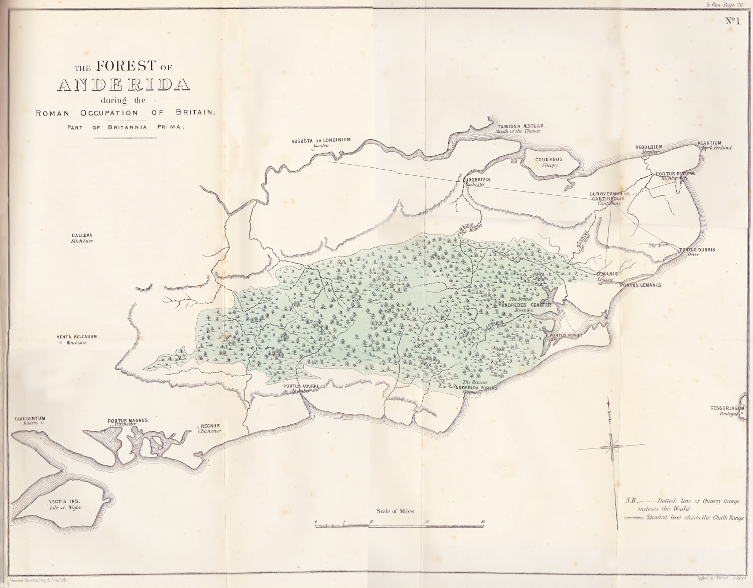
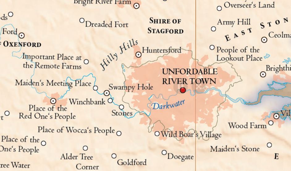
The typical settlement may develop at the bank of a river, atop an easily defended rocky outcropping, beside a sheltered bay, and many other such places that offer arable land, fish or game, or other ready source of food along with protections from storms and flooding or other natural disasters like fires, mudslides and volcanic eruptions. Even then, settlements may arise in inhospitable areas if that’s the only place to live close enough to rare resources like precious metals or gemstones. If the settlement exists along a trade route or main path of travel (for example, as a seaport conveniently located as a stopover point), it may grow. As it does, walls and fortifications develop and other structures are added to facilitate travel, trade, and mercantilism. Increasingly, housing for permanent and transient populations multiply and entertainment venues also develop. In a planned sense, a Roman settlement offers all of these, typically following a fairly uniform plan with a fortified camp, a forum and basilica, an amphitheater, several temples, markets, and bathhouses, all enclosed by a wall. As cities grow, they often incorporate other settlements and expand beyond the bounds of their original walls. Those existing structures may constrain development much the same way natural land features do.

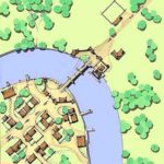
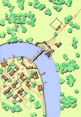
Ankh Morpork river crossing thumbnail by Charles D. F. Board

For all of the reasons enumerated, I think it’s great when an experienced urban planner offers up his rendition of the evolution of Terry Pratchett’s Ankh Morpork. Not only does it offer some great insights into how the great circular city might develop, but it allows for comparison to a similar riverine city like London from its beginning as a Roman settlement to its later habitation during Anglo-Saxon times and its later fortification in the Middle Ages.

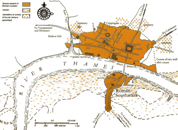
Roman London known extent with major structures

Mapping Monday: Artful Maps by Elizabeth Person

There’s nothing better than going out for the evening to a local pub and enjoying art on the walls in the form of beautiful maps by a local artist. These are one of my favorite kinds of maps and I love the hand-lettering. The colors convey a great deal of depth and the variety of the terrain the map illustrates. You can find more of Elizabeth Person’s work on her site.

Washington Map by Elizabeth Person – Puget Sound detail

Washington Map by Elizabeth Person – Cascades detail

Psi World Reading List

The Psi World game from FGU checks all the boxes. Dystopian future with possible cyberpunk overtones? Check. Persecuted minorities with psychic powers who are feared and hated for no reason? Check. Adventures that involve running from government forces and nefarious corporate-types with secret agendas? Check.

While many of the books on this list are about aliens with psychic powers living among us, they have more in common with the psionic humans in other books than their alien heritage would suggest. On the other hand, I’ve omitted books where the powers are simply technological in nature, such as Ramez Naam’s Nexus Trilogy or Linda Nagata’s The Bohr Maker. Similarly, the X-Men graphic novel God Loves Man Kills fits the genre tonally, but veers into the realm of superheroes rather than focusing on individuals whose powers are primarily mental and who are often limited in the strength of those powers or in the variety available to them. These are the books that inspired me and from which I drew the inspirations for the games I’ve run in this genre.

« Older posts Newer posts »

© 2024 Gaslight & Steam

Theme by Anders NorenUp ↑