Truth is always stranger than fiction and never more so than when looking at maps of places that have been touched by human hands. Filling swamps for warehouses and dredging of rivers for the passage of boats, as just one example, results in highly regular looking waterways and coastlines. Which is why a recent Twitter thread by James L. Sutter about New Orleans is so entertaining. The canal he points out particularly caught my attention because it’s such an absurd feature, but it’s part of a set of features that constitute the Gulf Intracoastal Waterway and it joins up with the Industrial Canal and the Mississippi River – Gulf Outlet Canal, where all three waterways allow traffic between Lake Ponchartrain and different parts of the Gulf.

New Orleans canal – James L Sutter tweet
That’s neat and all, but not so relevant to a fantasy setting that posits a High Medieval level of technology, even with the addition of magic and perhaps some manner of gargantuan beasts to assist with engineering tasks like dredging. But features like this, all criticism about “realism” aside, make for some fascinating visual accents and the most efficient way of moving people and goods is in a straight line. So if justifying canals in a straight line covering many tens of miles seems problematic and your setting doesn’t have the remains of some sort of advanced empire or forerunner civilization, consider an application of what exists in the setting. A nation with advanced engineering know-how can overcome a great deal of obstacles to built impressive roads, particularly in areas that are relatively flat, such as the roads built by the Romans in southern England. A large population dedicated to a single task, either united by a cause or enslaved to a smaller group of overseers, might overcome their deficit of expertise by simple brute force. Think, for example of the underground highways of the dwarves or the similar passages carved by Drow thralls in a traditional fantasy setting.
No matter what you do, creativity is the key and don’t limit your maps through lack of imagination. Conversely, I’ve seen so many maps of allegedly fantastic places that look like they were laid out by robots, ignoring terrain features and the simple wherewithal of the inhabitants to construct these ruler-straight roads and waterways. It’s the reason I hate the map of the Beklan Empire from Shardik by Richard Adams where roads and rivers often run in straight lines including one road that inexplicably arc from north to east in order to cross a river three times for no readily-apparent reason. In fairness, it’s been some time since I read the book, so I can’t recall if any of the setting features or origins are logically explained.
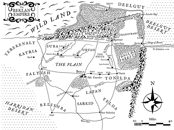
Beklan Empire from Shardik