The portfolio and blog of David Bennett

Month: May 2018

Mapping Monday: Adventures in Caves

As caves go, the Cave of Dunmore in County Kilkenny, Ireland, is a bit on the small side and not too terribly exceptional. As real-world locations go for the basis of game settings, there’s almost more going on in the visitor center than there is in the actual cave, apart from the somewhat dramatic sweep of the entrance that drops down steeply to the subterranean opening.

The story behind the cave and its history as the site of a Viking massacre is far more interesting and provides plenty of fodder for adventure, particularly if the dark atmosphere and reputation among the inhabitants is played up. For the gamemaster in a hurry, it’s relatively easy to make or find maps of limestone caves that are much more extensive and adapt them for adventure and to borrow all the description needed.

“we having, when led to the cavern for scenic illustration of the facts of this history, adventurously plunged our hand into the clear water, and taken therefrom a tibia of unusual length; and, indeed, the fact that such human relics are there to be seen, almost a quarter of a mile from the light of the earth, must, if we reject the peasant’s fine superstition, show us the misery of some former time of civil conflict, that could compel any wretched fugitive to seek, in the recesses and horrors of such a place, just as much pause as might serve him to starve, die, and rot.”
– from the Dublin Penny Journal, 1832.

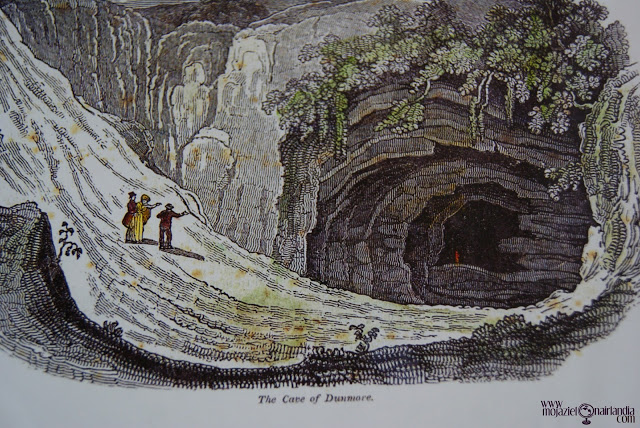
Colorized image of Cave of Dunmore via Moja Zielona Irlandia from the original in the Dublin Penny Journal

Mapping Monday: Video Game Levels

Levels for video games are curious beasts. Levels for games that have some degree of realism, such as first-person shooters and racing sims are even more curious. In many cases, the designers must balance the needs for those levels to be both visually interesting and fun to play while also bearing some semblance to the real world, even if that real world is filled with lava lakes and floating castles. Sometimes there are also technical constraints such as draw distances to contend with or the manner in which the in-game camera behaves. A recent visit to the Museum of Pop Culture (MoPOP) got me thinking about how simply lifting a real-world place to create a game level is generally a bad idea, though MoPOP is so thoroughly bizarre that it would work. In fact, it’s architecture is sufficiently confusing that the map provided to visitors doesn’t even try for a high level of detail and instead simply shows how the different areas are connected, either by halls, stairs, or elevators.

When I applied for my first game designer with Microsoft Games Studio, part of the application involved answering a series of questions about game design and called for the design of a sample Crimson Skies level. The idea was to build a simple (1 page) mission in the current Crimson Skies universe, limiting it to the weapons and planes in that setting. What I came up with was a raid in Appalachian Territory in order to clear the way for a bombing run on a band of Hell’s Henchmen.

Crimson Skies designer test – mission map

Crimson Skies designer test – mission description

Knowing what I know after having worked on the game, I’d add much more vertical elements to the game, exaggerating the depth of the river valley and break up the valley walls with ravines, add bluffs of varying heights, and increase the number of buildings. One of the areas in Crimson Skies: High Road to Revenge, the outlaw base of Sea Haven, was a caldera with exaggerated vertical scale with an exterior littered with the wreckage of zeppelins and an interior criss-crossed with walkways and girders. All of it made for interesting missions along with plenty of out-of-the-way places to hide tokens. Interestingly, the game was originally conceived with multi-modal play where the player would occasionally exit their plane and run around. When that idea was scrapped, there was no need for detailed human-scale areas and focus was given almost entirely to levels playable with airplanes apart from the gameplay around manning turrets.

Sea Haven main area level mesh in Maya for Crimson Skies

Sea Haven top view of main area level mesh in Maya for Crimson Skies

Mapping Monday: Kent Through Time

As a long-time fan of post-apocalyptic fiction and continuing last week’s discussion of toponyms, I thought I’d toss out three maps of the County of Kent in England. They’re very from very different time periods and the features on each are also dissimilar, but they’re all recognizable of the same area.

The first map is of Kent during the Roman occupation (and also covering Sussex, Surrey, and neighboring areas) that shows the extent of The Weald at that time (also known as Coit or Coed Andred, Silva Anderidae, or Andred’s Wood). Very little remains now apart from small forests like Ashdown Forest at the center of the High Weald and, incidentally, the basis for the setting of Winnie the Pooh stories. The second map is a postcard map of modern Kent (via Alwyn Ladell) that shows The Weald in the lower left. The third map is a future England as imagined by Russell Hoban for his book, Riddley Walker where the place names combine language drift and folk etymologies (or “eggcorns”). The place names are still recognizable in all three despite the changes in name over time.

As a case in point, all three maps feature the port city of Dover. On the first, it appears as Portus Dubris, a latinised name derived from the name given by the locals and meaning something like “river port” or “deep water port” (in the sense of the word “water” deriving from the root “deep”). The modern map features its present name, which is closest to the French name (Douvres). The imaginary future maps renders it as Do It Over, a curious expansion as a folk etymology like many other place names similar split and expanded in the book. The key in the map of the future is that it’s logically consistent with how names evolved from the names in the past.

The Forest of Anderida during the Roman Occupation of Britain from A History of The Weald of Kent with an outline of the Early History of the County, Volume I. by Robert Furley

Postcard map of Kent, the Garden of England. Drawn by M F Peck for J Salmon, Ltd., Sevenoaks.

Riddley Walker map of Kent from the book by Russell Hoban

Mapping Monday: Toponyms

One of the things I like as much as maps and geography is linguistics and anything related to the study of language. When it comes to maps, the naming of places is something I’m particularly fond of. Contrariwise, there’s nothing worse than encountering a map for a book or game adventure littered with the most overblown of PanCeltic place names or where the naming is intended to sound exotic through the addition of apostrophes (or sometimes both!).

I think one of the best ways to learn how to create realistic maps is to study real maps and to study why certain places are named the way they are. Names evolve and change over time as successive peoples enter an area and either use existing names given to places by their predecessors or attempt to translate them in some fashion. In some cases, the two cases (descriptive versus folk etymology) can be very hard to differentiate.

For those creating their own maps, there’s much more flexibility in the etymology of place names and the opportunity to play with the names while simultaneously developing the place names, cultures, history, and language of the area. Descriptive names are easy and incredibly common. Rivers are often named simply “River” such as England’s Thames, Tame, and Teme, and also Avon from a different root. The Atlas of True Names translates the Thames as Darkwater, but that seems more like over-etymologizing since the original root can be used to mean “dark” or “river”, implying that it would be more like a river in the sense of a dark and deep-flowing body of water, much like brook and torrent describe two very different types of streams. Other rivers are simply “river” with the addition of an adjective, such as Mississippi derived from the Ojibwe misi-ziibi (“great river”) or Tolkien’s Anduin and Brandywine (Baranduin).

Darkwater (River Thames) from the Atlas of True Names

So whether your fictional kingdom’s river is called The Long River or Darkwater or, simply, The River, there’s no wrong way to do it. Though I beg aspiring fantasy cartographers to not be too liberal with place names like Skull Mountain or Ul’za’kamm’dng. Simple and consistent is always better and you can get a lot of mileage out of simple fantasy base roots for river and mountain. For myself, I prefer Ered Luin to the Blue Mountains, but that might just be because I’m a fan of Elvish etymology, even if it is pretend.

© 2024 Gaslight & Steam

Theme by Anders NorenUp ↑